
ROZAS AIRBORNE RESEARCH CENTER
Web: https://www.inta.es/CIAR/es/
Address: 27271 Castro de Rei, Lugo.
Contact: ciar@inta.es
Who we are
The Rozas Airborne Research Center (CIAR) is a center belonging to the National Institute for Aerospace Technology (INTA), a public research organization.
It is a research center located at the Rozas Aerodrome, in Castro de Rei, Lugo, which offers the infrastructures and ground equipment necessary for the development of aircraft, their systems and equipment, and the evaluation of the campaigns to be carried out with them, so that they can be carried out efficiently and safely.
It is a center specialized in unmanned aircraft, both for experimental flights and on-board payloads.
The center has all the necessary procedures in place to operate safely.
Location and airspace
The Center is located in Castro de Rei, Lugo. It is located in uncontrolled airspace and does not affect restricted areas or recognized or protected natural areas.
From 1000ft onwards, the area of responsibility of LECG, whose natural and vertical limits are included in the AIP-Spain ENR 2.1, is penetrated in the TMA Galicia.

Facilities
It is a pioneering Test Center, where it is intended to integrate both Airborne Research Platforms (PAI) and new developments with unmanned aircraft (UAS).
A universal reference time base is available for all CIAR operations.
- Track
It has a paved runway 04/22 with dimensions 1200×40 m.
Exclusive airstrip with restricted airspace.
- Hangar
It has an enclosed hangar of approximately 1,600m
- Buildings
Workshop, hangar, meeting rooms, office space and work tools are available.
Video about the center
Equipment
Provides the necessary infrastructure and ground equipment for the development of aircraft and systems and the evaluation of the campaigns to be conducted with them, so that flights can be carried out efficiently and safely.
- Control center
Conceived as the operational core of the CIAR, composed of 5 operator positions, where the three basic and essential facets of the operation converge: operational safety, instrumentation and supervision of the user’s operation by INTA.
- Communications system
It has 5 control stations, with basic voice capabilities with air traffic control, other control centers and ground-to-air.
The system consists of 5 videoconferencing terminals, 2 loudspeakers (radio and intercom) for each operator station, 5 handsets with PTT, 1 recording system, 3 VHF transceivers with AM modulation and 1 UHF transceiver with AM and FM modulation.
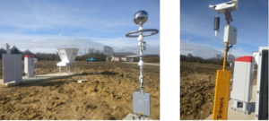
- On-site weather system
CIAR has surface meteorological information defined by the World Meteorological Organization in agreement with ICAO. Standard weather information is available for flights, with real-time management and forecast models for proper planning.
- Safety system
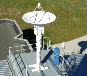
To ensure the safety of aircraft, it has a secondary radar that provides information on the center’s own and other air activity.
- Radar
IFF/SSR secondary radar with LVA antenna, with a minimum coverage of 180km, in any radial, in 360º azimuth depending on the orography and flight level from the ground up to 30,000ft.
System based on STANAG 4193 and ICAO Annex 10 requirements, operating in modes 1, 2, 3/A, C, mode S level 2, mode 4 and ADS-B IN.
- Weather Service
With lightning detector, rain gauge, visibility, visual range, cloud cover and cloud height, temperature and instantaneous wind direction and speed, average wind and wind gusts.
- Telemetry reception
Automatic and flexible tracking system, to be able to receive, distribute, process, display and store on the ground and in real time all the information transmitted by the systems in operation through radio frequencies for the S (2200-2400 MHz) and C (5091-5250 MHz) bands, performing an automatic tracking of the target.
- Drones System
It is a prototype for testing and certification in U-Space environment, which has B2B tools and services suitable for U-Space pre-flight management (strategic phase), in-flight management (tactical phase) and a specific strategic simulation tool.
The system has the functionality to: create conflict-free spaces, study planned scenarios, aircraft separation, adherence monitoring and conflict detection among others.
- Condor System
Portable system that makes radar data available at the ground station in addition to receiving any display from the control center.
It also allows the transmission of data received (in video format) in the control center to another location.