
EL ARENOSILLO EXPERIMENTATION CENTER
Web: www.inta.es
Address: Mazagón (Huelva)
Contact: Álvaro Gómez Villegas (Deputy Director) | (gomezva@inta.es)
Who we are
The test center of “El Arenosillo” (INTA/CEDEA) has been for fifty years the Official Test Site of the Spanish Ministry of Defense, used for the support of both Military and Civil Aircraft development programs, as well as sounding rockets. Initially conceived to provide an area suitable for sounding rocket launches, over time CEDEA expanded its activities to become a certification and qualification test center for manned and unmanned aircraft and their integration systems. It has also been used for qualification and quality control by the industry in general, and for aeronautical development systems in particular. Its clients belong to the Spanish and international Ministries of Defense and to the main aeronautical industries. In addition, INTA/CEDEA has supported numerous development programs for industry and governments. In this line, it has been an important support, providing testing means and their management, for military training tasks (armies, air forces and Spanish and international navies).
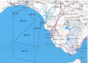
Location and airspace
The center is located in Mazagón (Huelva). Taking into account all the segregable airspace (LED119, LED120, LED121, LED122, LED128 and LED129) the test area reaches 150 km x 77 km and unlimited flight level (UNL).
Restricted areas may be reserved for users upon advance request, according to their needs.
technical requirements for testing. With regard to the time slots, they will be available according to
of the needs of the tests without limitations.

Facilities
The CEDEA is a flexible 24-hour facility, certified by NATO, the EU and ESA as a Security Control Office. The maximum classification level for stored information and data is NATO SECRET/ EU SECRET/ ESA SECRET while restricted access areas are class II.
Its facilities include:
- Management building
It has a multimedia room with capacity for 40 people and equipped for real-time observation of rehearsals.
- Offices
Separate office buildings are available to clients, equipped with internet connection and the possibility of NATO security classification.
- Track
Compacted earth track 30-120, 400m long and 30m wide.
- RPAS launch platform
40x40m reinforced concrete platform located on the coastline and 34m in height (amsl)
- Test field control center
Equipped with the necessary means for the coordination of tests to guarantee the integrity of the segregated maritime-air space. In addition, it provides the process, representation and distribution in real time of the trajectories of the tested elements and their recording for later treatment.
- RPAS Control Center
It houses the control stations of the RPA systems tested or operated in the field. It has direct communication with the field control center and trajectory data provided by it.
- Hangars
Two hangars with specific tooling for the operation of both reciprocating and jet engine RPAS.
Rocket assembly hangar, qualified to work with explosive elements.
Several hangars and warehouses for equipment storage.
- Heliports, powder magazine, meteorological services
Three designated areas for helicopter takeoff and landing.
Powder magazine for explosives storage.
100m high meteorological and communications tower.
Equipment
INTA/CEDEA is able to support multiple test scenarios due to its flexible structure, based on a redundant instrumentation system. A sensor network consisting of optronic systems, radars, IR cameras and telemetry is adapted to the different test scenarios to meet the requirements, whether testing airborne platforms, targets (air or sea), different types of ammunition, missiles, or any other system to be verified, qualified or certified.
- Optronic systems
Four optronic stations according to the following capacities:
-
- 5 , high-speed film camera (up to 500 fps) with a focal length of 1.5 m to 3 m and a focal aperture of 0.32 m.
- IR sensor (8 to 12 μm) and field of view of 1.5º.
- Multi-focal length TV camera with selectable focal lengths (1, 2.5 and 5 m) with 0.19 m focal aperture
- Range RADAR, K-Band, 34 GHz with 40 km maximum range and moving target indicator, being able to continue tracking up to 1280 m/s target speed with 1 m accuracy.
- Acquisition camera with autofocus and zoom from 2.45º to 27.5º.
- Telemetry antennas with integrated receiver.
- Automatic tracking unit that processes in real time the video signal, up to 5 targets and simultaneous tracking.
- Dynamic behavior: 100º/s
- Angular accuracy < 0.75 arcsec
- RIR 778 Trajectory Radar RIR 778
- Frequency 8.5 to 9.6 GHz
- Peak power 250 kW
- Beam width, 1º
- Antenna gain, 41 dBi
- Angular resolution, 0.3 mRad
- Resolution in range, 3m
- Angular velocity is tracked, 30º/s
- SKIN & BEACON, TV, and IR tracking modes
- RIR 778C Trajectory Radar RIR 778C
- Frequency 5.4 to 5.9 GHz
- Peak power 1 MW
- Beam width, 1º
- Antenna gain, 41 dBi
- Angular resolution, 0.2 mRad
- Resolution in range, 3 m
- Angular velocity is tracked, 35º/s
- SKIN & BEACON, TV, and IR tracking modes
- RIR 779C Trajectory Radar RIR 779C
- Frequency 5.4 to 5.9 GHz
- Peak power 1 MW
- Beam width, 0.8º Beam width, 0.8º Beam width, 0.8º Beam width, 0.8
- Antenna gain, 46 dBi
- Angular resolution, 0.1 mRad
- Resolution in range, 3 m
- Angular velocity is tracked, 30º/s
- SKIN & BEACON, TV and IR tracking modes
- Telemetry antenna with auto-tracking for S and C band
Two interchangeable feeders for operating frequency bands: S or C
-
- Only 5 minutes to make the change
- Minimizes the cross section of the feeder
- Reduces filter complexity to meet both bands
- More efficient than a double feeder
Video and data capabilities
Two types of outputs:
-
- 1 channel for Azimuth and Elevation. To set the radial position
- 1 channel for GPS data position. Complete
- Telemetry station
It transforms the radio frequency signal into digital or analog data to be recorded. The main features of the telemetry station are:
-
- TM Reception in S and C Band
- 2 Analog 2MHz BW recorders
- 2 12Mb/s digital recorders
- Demultiplexer: 20 channels
- 2 independent systems for de-multiplexing, processing and presentation.
- Communications
CEDEA is a flexible facility in terms of communications. Two means of communication (main and backup) are always available during each operation and to all personnel involved.
-
- IP voice stations connected to the internal fiber optic network
- Portable radiofrequency stations with zig-zagging capability
- HF 1.5-30 MHz. Output power, 100 W (1,000 W)
- VHF 115-173.98 MHz (FM) and 115 -149.98 MHz (AM). Output power 10 W (50 W)
- UHF 225-420 MHz (FM) and 225-399.98 MHz (AM). Output power 10 W (50 W)
- Flight Termination System (FTS)
The main features of the FTS are:
-
- Complete redundant system
- Carrier frequency from 370 to 450 MHz
- Output power 1,000 W
- Modes:
- IRIG
- High Alphabet
- Enhanced Flight Termination System (EFTS). Encryption if necessary